Back মেহেরপুর জেলা Bengali/Bangla মেহেরপুর জিলা BPY Meherpur CEB Meherpur (Distrikt) German Meherpur (zila) Spanish ناحیه مهرپور Persian Meherpur (district) French मेहरपुर जिला Hindi Distretto di Meherpur Italian 메헤르푸르구 Korean
Meherpur District
মেহেরপুর | |
|---|---|
 Image of Mujibnagar Memorial | |
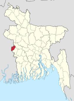
 Location of Meherpur District in Bangladesh | |
 Expandable map of Meherpur District | |
| Coordinates: 23°45′N 88°42′E / 23.75°N 88.70°E | |
| Country | |
| Division | Khulna |
| Headquarters | Meherpur |
| Area (2022)[1] | |
• Total | 741.62 km2 (286.34 sq mi) |
| Population | |
• Total | 705,356 |
| • Density | 950/km2 (2,500/sq mi) |
| Demonym | Meherpur |
| Time zone | UTC+06:00 (BST) |
| Postal code | 7100 |
| Area code | 0791 |
| ISO 3166 code | BD-39 |
| HDI (2019) | 0.644[3] medium · 5th of 20 |
| Website | meherpur |
Meherpur (Bengali: মেহেরপুর, pron: meɦeɾpuɾ) is the northwestern district of Khulna Division in southwestern Bangladesh. It is bordered by the Indian state of West Bengal to the west, and by the Bangladeshi districts of Kushtia and Chuadanga to the east.[4] Pre-independence Meherpur was a subdivision of Nadia district.[5] The district has an area of 716.08 square kilometres (276.48 sq mi).
- ^ Population and Housing Census 2022 - District Report: Meherpur (PDF). District Series. Dhaka: Bangladesh Bureau of Statistics. June 2024. ISBN 978-984-475-241-2.
- ^ Cite error: The named reference
2022censuswas invoked but never defined (see the help page). - ^ "Sub-national HDI - Area Database - Global Data Lab". hdi.globaldatalab.org. Retrieved 2020-03-18.
- ^ Md Abu Hasan Farooque (2012). "Meherpur District". In Sirajul Islam; Miah, Sajahan; Khanam, Mahfuza; Ahmed, Sabbir (eds.). Banglapedia: the National Encyclopedia of Bangladesh (Online ed.). Dhaka, Bangladesh: Banglapedia Trust, Asiatic Society of Bangladesh. ISBN 984-32-0576-6. OCLC 52727562. OL 30677644M. Retrieved 27 November 2024.
- ^ "Nadia keeps a date with history | Kolkata News". The Times of India. Aug 19, 2011. Retrieved 2022-02-23.